Altitude: 694m to 1556m. Gain: 1700m. Loss: 2005m . Gradient: 16 deg (Moderate-hard)
Skills: Occasional scrambles (3/7) - Streams (2/6) Winter - Iceaxe/crampons, avalanche risk (5/7)
A tough tops route with 2 steep scree passes - good fun but a scramble in places.
From Home Hill Hut, either a) climb above the hut to the tops and follow them to pt1312, or b) sidle the bushedge and climb the obvious tussock gully below pt1312. If on the tops, the north face of pt1388 is sidleable 20m below the crest, but steep on scree/loose rock and care is required. An ice-axe or pole is advised.
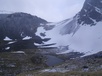
From pt1312 follow the contour into the head of the unnamed creek to your left (south), which flows SE. There are two V-notches in western face of the head-basin, and you are aiming for the southern of the two. Climb scree (I had ice/snow to climb in mid-November) to the pass. On the far side drop down the steep scree face to the small tarn visible 150m directly below (not shown on maps). Again this basin has snow/ice in November.
Climb the small face beyond the tarn and sidle the northern valeyside at that height on good scree terraces until you are above the larger tarn shown on the map. Drop down tussock faces to the tarn. From here an easy climb follows up the steady slope NW to the valley head on a mixture of large scree and tussock (again, ice in November).
I had terrible weather so did not investigate other options into Steele Creek - I simply continued NW dropping down the scree gully beyond the pass (east of pt1548). This feels as if it will bluff-out any moment, but I got to 100m below the start of beech forest before I hit the first waterfalls. A good, easy descent on scree all the way.
Above the first waterfall a brief scramble up a steep scrubby gut on the left provided access to the spur to the west. Beyond, a moderately-steep face of open beech made for an easy descent back to the creek we'd been following - hitting it in the broad shingle valley shown on the maps below the section of falls.
From here a simple walk took up the reaming 500m to the main Steele Creek, and a further 2km down the broad, open river flats followed to Steele Creek Hut - situated on the western (opposite) bank just where the flats end. The crossing of Steele Creek was shin-deep after 5 hours of gentle drizzle/snow.