Altitude: 778m to 1546m. Gain: 1592m. Loss: 900m . Gradient: 19 deg (Moderate)
Skills: Alpine weather (2/7) - Streams (2/6)
The "low" route to Shotover Saddle goes up Tyndall Creek. Records from the Tummel Burn Hut book dating back to the 70s don't recommend this route, neither does Moirs. The "high" route follows the spine of the ridge from Point 1550 over Peak 1781 and along the 1600m contour to Shotover Saddle. This would make a good route going from the saddle to Tummel Burn Hut. The "middle route" climbs to above the scrub line then sidles up the valley between the 1200 and 1300 meter contour before crossing Tyndall Burn at 1200m and climbing to the saddle on the true right of the main stream.
Note that the attached gpx route drops too low in the middle section of the sidle and has to climb again - this can be avoided by not dropping whilst sidling.
From Tummel Burn Hut look for a metal sign hanging from a bush on the true left of Tyndall Creek across from the hut. An ancient overgrown NZFS track sporadically marked with permalot makers pushes up the hill through bush through a fern chocked gully to the northwest from the river. Push through the ferns and light scrub in the bush, climbing until a dry creek bed is reached running northeast to southwest. There were 2 cairns here in Feb 2016.
Climb the creek bed sticking to it until dead trees from an old scrub fire are passed. Keep an eye out for a cairn which supposedly marks the turnoff to head due east from the creek bed. We missed it, but the creek bed terminates in a wall of scrub. A small, scrub filled off shoot from the main creek bed headed east from here. A short scrub bash eastwards out of the main creek bed and around the top of the off shoot bed through man eating scrub allowed us to reach a point where a metal warahtah stake with a permalot marker attached could be seen. The waratah marks the start point of a light trail which ran up the ridge line through thinning scrub and on to the open tussock slopes of the main ridge at about 1200 metres. If you are coming down then the waratah would be the point to head west to locate the dry creek bed.
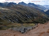
From 1200m sidle tussock slopes through numerous gullies and interesting rock formations up valley until the big spur coming down from Peak 1781 is reached and the upper valley and creeks can be viewed. Descend to cross a gulch with the biggest tributary in it and make your way around to the main stream of Tyndall Creek, crossing it at about 1200m. Climb up tussock slopes on the true right of the stream to the small tarn shown on the map, there is good camping here or at the 2nd mapped tarn further to the east although that one is more exposed to wind coming over from the Matukituki. Its a short further climb up onto the saddle. On the north side of the saddle its a short steep descent down to the large tarn shown on the map which is sheltered from the south.
Red Rock makes for an interesting hour round side trip to a random patch of red ultramafic rock such as whats found in the Olivines to the west.